Package com.luciad.tea
Class TLcdLOSFactory
java.lang.Object
com.luciad.tea.TLcdLOSFactory
Deprecated.
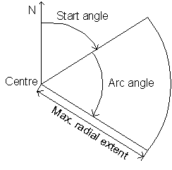
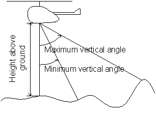
This is a Factory class to create an ILcdLineOfSightCoverage based on visual contact.
To establish the range of the coverage all methods will require the following
operational parameters:
- aArcAngle
- aAngleStepSize
- aMaxRadius
- aMinverticalAngle
- aMaxverticalAngle
|
|
-
Constructor Summary
Constructors -
Method Summary
Modifier and TypeMethodDescriptioncreateLOSCoverage(ILcdPoint aCenter, double aHeightAboveGround, double aStartAngle, double aArcAngle, double aAngleStepSize, double aMaxRadius, double aMinVerticalAngle, double aMaxVerticalAngle, ILcdRaster[] aRasters) Deprecated.Creates a newILcdLineOfSightCoveragerepresenting the results of a line-of-sight computation.createLOSCoverage(ILcdPoint aCenter, double aHeightAboveGround, double aStartAngle, double aArcAngle, double aMaxRadius, ILcdRaster[] aRasters) Deprecated.use createLOSCoverage with min and max vertical angle parameters.createLOSCoverage(ILcdPoint aCenterPoint, ILcdGeoReference aCenterPointReference, double aHeightAboveGround, double aAngleStart, double aAngleArc, double aAngleStep, double aRadiusMax, double aRadiusStep, double aMinVerticalAngle, double aMaxVerticalAngle, ALcdTerrainElevationProvider aTerrainElevationProvider, ILcdGeoReference aTargetReference, double aTargetPixelDensity, TLcdCoverageFillMode aFillMode, TLcdCoverageAltitudeMode aAltitudeMode) Deprecated.Creates a newILcdExtendedLineOfSightCoveragerepresenting the results of a line-of-sight computation.createLOSCoverage(ILcdPoint aCenter, ILcdGeoReference aCenterPointReference, double aHeightAboveGround, double aStartAngle, double aArcAngle, double aAngleStepSize, double aMaxRadius, double aMinVerticalAngle, double aMaxVerticalAngle, ALcdTerrainElevationProvider aTerrainElevationProvider, ILcdGeoReference aTargetReference, double aTargetPixelDensity, double aSampleDensity, TLcdCoverageFillMode aFillMode, TLcdCoverageAltitudeMode aAltitudeMode) Deprecated.Creates a newILcdExtendedLineOfSightCoveragerepresenting the results of a line-of-sight computation.createLOSCoverage(ILcdPoint aCenter, ILcdGeoReference aCenterPointReference, double aHeightAboveGround, double aStartAngle, double aArcAngle, double aMaxRadius, double aMinVerticalAngle, double aMaxVerticalAngle, ILcdRaster[] aRasters, ILcdGeoReference aRastersReference, ILcdGeoReference aTargetReference, TLcdCoverageFillMode aFillMode, TLcdCoverageAltitudeMode aAltitudeMode) Deprecated.Convenience method for line-of-sight computations over elevation data which consists entirely of raster data defined in one reference.createLOSCoverage(ILcdPoint aCenter, ILcdGeoReference aCenterPointReference, double aHeightAboveGround, double aStartAngle, double aArcAngle, double aMaxRadius, double aMinVerticalAngle, double aMaxVerticalAngle, ALcdTerrainElevationProvider aTerrainElevationProvider, ILcdGeoReference aTargetReference, double aTargetPixelDensity, double aSampleDensity, double aRadialFraction, TLcdCoverageFillMode aFillMode, TLcdCoverageAltitudeMode aAltitudeMode) Deprecated.Creates a newILcdExtendedLineOfSightCoveragerepresenting the results of a line-of-sight computation.
-
Constructor Details
-
TLcdLOSFactory
public TLcdLOSFactory()Deprecated.
-
-
Method Details
-
createLOSCoverage
public ILcdLineOfSightCoverage createLOSCoverage(ILcdPoint aCenter, double aHeightAboveGround, double aStartAngle, double aArcAngle, double aAngleStepSize, double aMaxRadius, double aMinVerticalAngle, double aMaxVerticalAngle, ILcdRaster[] aRasters) Deprecated.Creates a newILcdLineOfSightCoveragerepresenting the results of a line-of-sight computation. If an object is only visible from a height larger than the maximum short value (Short.MAX_VALUE), this maximum value will be set for the corresponding pixel. This method is assumes a center point and rasters defined in the geodetic WGS84 reference. See the images at the top of the class documentation to clarify the interpretation of the angles.- Parameters:
aCenter- TheILcdPointfrom where the computation is performed. Only x- and y-coordinates are taken into account. Height is given by aHeightAboveGroundaHeightAboveGround- The height above the ground (in meter) at the center point, from where the computation is performedaStartAngle- The start angle in degrees as compass position (i.e. starting from 12 o'clock position, positive clockwise)aArcAngle- The arc angle in degrees, positive clockwise. The arc angle should be positive.aAngleStepSize- The angular discretization step size in degreesaMaxRadius- The maximum radial extent in metersaMinVerticalAngle- the minimum angle of the vertical extent in degrees,starting from 0 at the ground to 180 at zenith.aMaxVerticalAngle- the maximum angle of the vertical extent in degrees,starting from 0 at the ground to 180 at zenith.aRasters- The differentILcdRasterthat are taken into account in computing theILcdLineOfSightCoverage. At least one of the rasters provided should contain the center of theILcdLineOfSightCoverage. Otherwise,nullis returned as result of the factory method.- Returns:
- An
ILcdLineOfSightCoveragecontaining the results of a line-of-sight computation with the given parameters.
-
createLOSCoverage
public ILcdExtendedLineOfSightCoverage createLOSCoverage(ILcdPoint aCenter, ILcdGeoReference aCenterPointReference, double aHeightAboveGround, double aStartAngle, double aArcAngle, double aMaxRadius, double aMinVerticalAngle, double aMaxVerticalAngle, ILcdRaster[] aRasters, ILcdGeoReference aRastersReference, ILcdGeoReference aTargetReference, TLcdCoverageFillMode aFillMode, TLcdCoverageAltitudeMode aAltitudeMode) Deprecated.Convenience method for line-of-sight computations over elevation data which consists entirely of raster data defined in one reference. This method creates an elevation provider and finds the raster density at the center point and then passes on tocreateLOSCoverage(com.luciad.shape.ILcdPoint, com.luciad.reference.ILcdGeoReference, double, double, double, double, double, double, double, double, ALcdTerrainElevationProvider, com.luciad.reference.ILcdGeoReference, double, TLcdCoverageFillMode, TLcdCoverageAltitudeMode)The radial factor is equal at 1.0 at 70km, decreasing inversely with the max radius from there on. If an object is only visible from a height larger than the maximum short value (Short.MAX_VALUE), this maximum value will be set for the corresponding pixel.- Parameters:
aCenter- theILcdPointfrom where the computation is performed. Only x- and y-coordinates are taken into account. Height is given by aHeightAboveGround.aCenterPointReference- the reference the center point is defined in.aHeightAboveGround- the height above the ground (in meter) at the center point, from where the computation is performed.aStartAngle- the start angle in degrees as compass position (i.e. starting from 12 o'clock position, positive clockwise).aArcAngle- the arc angle in degrees, positive clockwise. The arc angle should be positive.aMaxRadius- the maximum radial extent in meters.aMinVerticalAngle- the minimum angle of the vertical extent in degrees,starting from 0 at the ground to 180 at zenith.aMaxVerticalAngle- the maximum angle of the vertical extent in degrees,starting from 0 at the ground to 180 at zenith.aRasters- the rasters representing the elevation data.aRastersReference- the reference the rasters are defined in.aTargetReference- the reference of the resulting line-of-sight coverage.aFillMode- how the raster should be filled. Possible choices are:- maximum: the pixel value corresponds to the maximum value found in computations for that pixel.
- minimum: the pixel value corresponds to the minimum value found in computations for that pixel.
- nearest neighbor: the pixel value corresponds to the value computed nearest to the bottom left of the pixel location.
aAltitudeMode- the altitude mode expresses whether the result should be interpreted as height above ground, above geoid or above ellipsoid. If null is passed, above ground is assumed.- Returns:
- An
ILcdExtendedLineOfSightCoveragecontaining the results of a line-of-sight computation with the given parameters.
-
createLOSCoverage
public ILcdExtendedLineOfSightCoverage createLOSCoverage(ILcdPoint aCenter, ILcdGeoReference aCenterPointReference, double aHeightAboveGround, double aStartAngle, double aArcAngle, double aMaxRadius, double aMinVerticalAngle, double aMaxVerticalAngle, ALcdTerrainElevationProvider aTerrainElevationProvider, ILcdGeoReference aTargetReference, double aTargetPixelDensity, double aSampleDensity, double aRadialFraction, TLcdCoverageFillMode aFillMode, TLcdCoverageAltitudeMode aAltitudeMode) Deprecated.Creates a newILcdExtendedLineOfSightCoveragerepresenting the results of a line-of-sight computation. This method computes a angle and radial step size from the given sample density and the radial fraction and then passes these parameters to the methodcreateLOSCoverage(com.luciad.shape.ILcdPoint, com.luciad.reference.ILcdGeoReference, double, double, double, double, double, double, double, double, ALcdTerrainElevationProvider, com.luciad.reference.ILcdGeoReference, double, TLcdCoverageFillMode, TLcdCoverageAltitudeMode). If an object is only visible from a height larger than the maximum short value (Short.MAX_VALUE), this maximum value will be set for the corresponding pixel.- Parameters:
aCenter- theILcdPointfrom where the computation is performed. Only x- and y-coordinates are taken into account. Height is given by aHeightAboveGround.aCenterPointReference- the reference the center point is defined in.aHeightAboveGround- the height above the ground (in meter) at the center point, from where the computation is performed.aStartAngle- the start angle in degrees as compass position (i.e. starting from 12 o'clock position, positive clockwise).aArcAngle- the arc angle in degrees, positive clockwise. The arc angle should be positive.aMaxRadius- the maximum radial extent in meters.aMinVerticalAngle- the minimum angle of the vertical extent in degrees,starting from 0 at the ground to 180 at zenith.aMaxVerticalAngle- the maximum angle of the vertical extent in degrees,starting from 0 at the ground to 180 at zenith.aTerrainElevationProvider- an elevation provider that is able to provide elevation information for all points within a distance aMaxRadius of the center point. It should support retrieving elevations in the WGS84 reference and the center point reference.aTargetReference- the reference of the resulting line-of-sight coverage.aTargetPixelDensity- the pixel density the resulting line-of-sight coverage should have. This is the average number of pixels in an area of 1 by 1 in model coordinates. Higher densities will lead to more detailed coverages of the area. Note that the result is bound by the density of the samples taken of the underlying terrain data (which depends on the radial and angular step sizes). The size occupied in memory by the coverage will increase linearly with this density.aSampleDensity- the density of the data sampling, expressed in the target reference. This is the average number of samples that will be taken for an area equal to 1 square unit in model reference. For a geodetic target references this is the average number of samples for an area of 1 degree latitude by 1 degree longitude, for grid target references this is usually (depends on the unit of measure of the reference) the average number of samples per meter square. From this parameter the radial and angular step for sampling are computed. The higher the density, the more accurate the result will be, but computation time will de/increase linearly with sample density. Note that this does not influence the density of the resulting raster, a higher sampling density will provide more data for one pixel of the raster. Which of these value is chosen depends on the fill mode parameter. Reasonable values are usually the densities of the underlying rasters, provided they have the same reference as the target reference.aRadialFraction- a number in the interval ]0,1] which indicates up until which fraction of aMaxradius every pixel of the result should be represented by at least one computation. Even when the fill mode is not equal to nearest neighbor it is guaranteed that there will be no 'holes' in the raster up until this fraction. Computation time will de/increase linearly with the radial fraction.aFillMode- how the raster should be filled. Possible choices are:- maximum: the pixel value corresponds to the maximum value found in computations for that pixel.
- minimum: the pixel value corresponds to the minimum value found in computations for that pixel.
- nearest neighbor: the pixel value corresponds to the value computed nearest to the bottom left of the pixel location.
aAltitudeMode- the altitude mode expresses whether the result should be interpreted as height above ground, above geoid or above ellipsoid. If null is passed, above ground is assumed.- Returns:
- An
ILcdExtendedLineOfSightCoveragecontaining the results of a line-of-sight computation with the given parameters.
-
createLOSCoverage
public ILcdExtendedLineOfSightCoverage createLOSCoverage(ILcdPoint aCenter, ILcdGeoReference aCenterPointReference, double aHeightAboveGround, double aStartAngle, double aArcAngle, double aAngleStepSize, double aMaxRadius, double aMinVerticalAngle, double aMaxVerticalAngle, ALcdTerrainElevationProvider aTerrainElevationProvider, ILcdGeoReference aTargetReference, double aTargetPixelDensity, double aSampleDensity, TLcdCoverageFillMode aFillMode, TLcdCoverageAltitudeMode aAltitudeMode) Deprecated.Creates a newILcdExtendedLineOfSightCoveragerepresenting the results of a line-of-sight computation. This method computes a radial step size from the given sample density and then passes these parameters to the methodcreateLOSCoverage(com.luciad.shape.ILcdPoint, com.luciad.reference.ILcdGeoReference, double, double, double, double, double, double, double, double, ALcdTerrainElevationProvider, com.luciad.reference.ILcdGeoReference, double, TLcdCoverageFillMode, TLcdCoverageAltitudeMode). If an object is only visible from a height larger than the maximum short value (Short.MAX_VALUE), this maximum value will be set for the corresponding pixel.- Parameters:
aCenter- theILcdPointfrom where the computation is performed. Only x- and y-coordinates are taken into account. Height is given by aHeightAboveGround.aCenterPointReference- the reference the center point is defined in.aHeightAboveGround- the height above the ground (in meter) at the center point, from where the computation is performed.aStartAngle- the start angle in degrees as compass position (i.e. starting from 12 o'clock position, positive clockwise).aArcAngle- the arc angle in degrees, positive clockwise. The arc angle should be positive.aAngleStepSize- the angular step in degrees, positive clockwise.aMaxRadius- the maximum radial extent in meters.aMinVerticalAngle- the minimum angle of the vertical extent in degrees,starting from 0 at the ground to 180 at zenith.aMaxVerticalAngle- the maximum angle of the vertical extent in degrees,starting from 0 at the ground to 180 at zenith.aTerrainElevationProvider- an elevation provider that is able to provide elevation information for all points within a distance aMaxRadius of the center point. It should support retrieving elevations in the WGS84 reference and the center point reference.aTargetReference- the reference of the resulting line-of-sight coverage.aTargetPixelDensity- the pixel density the resulting line-of-sight coverage should have. This is the average number of pixels in an area of 1 by 1 in model coordinates. Higher densities will lead to more detailed coverages of the area. Note that the result is bound by the density of the samples taken of the underlying terrain data (which depends on the radial and angular step sizes). The size occupied in memory by the coverage will increase linearly with this density.aSampleDensity- the density of the data sampling, expressed in the target reference. This is the average number of samples that will be taken for an area equal to 1 square unit in model reference. For a geodetic target references this is the average number of samples for an area of 1 degree latitude by 1 degree longitude, for grid target references this is usually (depends on the unit of measure of the reference) the average number of samples per meter square. From this parameter the radial and angular step for sampling are computed. The higher the density, the more accurate the result will be, but computation time will de/increase linearly with sample density. Note that this does not influence the density of the resulting raster, a higher sampling density will provide more data for one pixel of the raster. Which of these value is chosen depends on the fill mode parameter. Reasonable values are usually the densities of the underlying rasters, provided they have the same reference as the target reference.aFillMode- how the raster should be filled. Possible choices are:- maximum: the pixel value corresponds to the maximum value found in computations for that pixel.
- minimum: the pixel value corresponds to the minimum value found in computations for that pixel.
- nearest neighbor: the pixel value corresponds to the value computed nearest to the bottom left of the pixel location.
aAltitudeMode- the altitude mode expresses whether the result should be interpreted as height above ground, above geoid or above ellipsoid. If null is passed, above ground is assumed.- Returns:
- An
ILcdExtendedLineOfSightCoveragecontaining the results of a line-of-sight computation with the given parameters.
-
createLOSCoverage
public ILcdExtendedLineOfSightCoverage createLOSCoverage(ILcdPoint aCenterPoint, ILcdGeoReference aCenterPointReference, double aHeightAboveGround, double aAngleStart, double aAngleArc, double aAngleStep, double aRadiusMax, double aRadiusStep, double aMinVerticalAngle, double aMaxVerticalAngle, ALcdTerrainElevationProvider aTerrainElevationProvider, ILcdGeoReference aTargetReference, double aTargetPixelDensity, TLcdCoverageFillMode aFillMode, TLcdCoverageAltitudeMode aAltitudeMode) Deprecated.Creates a newILcdExtendedLineOfSightCoveragerepresenting the results of a line-of-sight computation. If an object is only visible from a height larger than the maximum short value (Short.MAX_VALUE), this maximum value will be set for the corresponding pixel. See the images at the top of the class documentation to clarify the interpretation of the angles.- Parameters:
aCenterPoint- theILcdPointfrom where the computation is performed. Only x- and y-coordinates are taken into account. Height is given by aHeightAboveGround.aCenterPointReference- the reference the center point is defined in.aHeightAboveGround- the height above the ground (in meter) at the center point, from where the computation is performed.aAngleStart- the start angle in degrees as compass position (i.e. starting from 12 o'clock position, positive clockwise).aAngleArc- the arc angle in degrees, positive clockwise. The arc angle should be positive.aAngleStep- the angular step in degrees, positive clockwise.aRadiusMax- the maximum radial extent in meters.aRadiusStep- the radial step in meters.aMinVerticalAngle- the minimum angle of the vertical extent in degrees,starting from 0 at the ground to 180 at zenith.aMaxVerticalAngle- the maximum angle of the vertical extent in degrees,starting from 0 at the ground to 180 at zenith.aTerrainElevationProvider- an elevation provider that is able to provide elevation information for all points within a distance aRadiusMax of the center point. It should support retrieving elevations in the WGS84 reference and the center point reference.aTargetReference- the reference of the resulting line-of-sight coverage.aTargetPixelDensity- the pixel density the resulting line-of-sight coverage should have. This is the average number of pixels in an area of 1 by 1 in model coordinates. Higher densities will lead to more detailed coverages of the area. Note that the result is bound by the density of the samples taken of the underlying terrain data (which depends on the radial and angular step sizes). The size occupied in memory by the coverage will increase linearly with this density.aFillMode- how the raster should be filled. Possible choices are:- maximum: the pixel value corresponds to the maximum value found in computations for that pixel.
- minimum: the pixel value corresponds to the minimum value found in computations for that pixel.
- nearest neighbor: the pixel value corresponds to the value computed nearest to the bottom left of the pixel location.
aAltitudeMode- the altitude mode expresses whether the result should be interpreted as height above ground, above geoid or above ellipsoid. If null is passed, above ground is assumed.- Returns:
- An
ILcdExtendedLineOfSightCoveragecontaining the results of a line-of-sight computation with the given parameters.
-
createLOSCoverage
public ILcdLineOfSightCoverage createLOSCoverage(ILcdPoint aCenter, double aHeightAboveGround, double aStartAngle, double aArcAngle, double aMaxRadius, ILcdRaster[] aRasters) Deprecated.use createLOSCoverage with min and max vertical angle parameters.Provided for backward compatibility.- Parameters:
aCenter- TheILcdPointfrom where the computation is performed. Only x- and y-coordinates are taken into account. Height is given by aHeightAboveGroundaHeightAboveGround- The height above the ground (in meter) at the center point, from where the computation is performedaStartAngle- The start angle in degrees as compass position (i.e. starting from 12 o'clock position, positive clockwise)aArcAngle- The arc angle in degrees, positive clockwise. The arc angle should be positive.aMaxRadius- The maximum radial extent in metersaRasters- The differentILcdRasterthat are taken into account in computing theILcdLineOfSightCoverage. At least one of the rasters provided should contain the center of theILcdLineOfSightCoverage. Otherwise,nullis returned as result of the factory method.- Returns:
- An
ILcdLineOfSightCoveragecontaining the results of a line-of-sight computation with the given parameters. If no computations could be done the result will be null.
-
TLcdLOSCoverageFactoryinstead. Perform the following steps to replace this code with the new line-of-sight coverage functionality.TLcdLOSCoverageFactory.TLcdLOSRadarPropagationFunction).TLcdLOSCoverage) which contains the coverage for which the line-of-sight should be created.TLcdLOSCoverageFactory.createLOSCoverageMatrixto create a new line-of-sight coverage matrix.TLcdLOSCoverageFactory.createLOSCoverageRasterto create a new line-of-sight coverage raster.