Package com.luciad.transformation
package com.luciad.transformation
Handles all transformations between model coordinates and world coordinates.
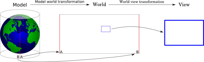
The model coordinate system is defined by the model, e.g. longitude/latitude coordinate pairs representing the locations of cities in the world. It is defined with respect to a model reference, e.g. WGS-84.
The world coordinate system is a common cartesian space for viewing one or more models. It is defined with respect to a world reference. It differs from the screen coordinate system only by a translation and a scaling, as is illustrated by the image below.
- Since:
- 1.0
-
ClassDescriptionAn
ILcdModelModelTransformationdefines the transformation between model data in a source reference and model data in another model reference.AnILcdModelXYWorldTransformationdefines the transformation between model data and world data in a XY coordinate plane, which is also denoted as a world point or world coordinate.AnILcdModelXYZWorldTransformationdefines the transformation between model data and world data in XYZ coordinate plane.Describes a transformation from model z values to world z values.A topocentric earth fixed cartesian coordinate system is a right-handed cartesian coordinate system defined with respect to an ellipsoid and a point on the ellipsoid.AnILcdXYWorldXYWorldTransformationdefines the transformation between two world reference systems.A hybrid 2d and 3d transformation.Utility class to transform points and bounds betweenILcdModelReferenceimplementations.Default implementation of ILcdModelXYWorldTransformation.Default implementation ofILcdModelXYZWorldTransformation.ThisILcdModelXYWorldTransformationdefines a transformation between anILcdGeocentricReferenceand anILcdXYWorldReference.ThisILcdModelXYZWorldTransformationdefines a transformation between anILcdGeodeticReferenceand anILcdGeocentricReference.ThisILcdModelXYWorldTransformationdefines a transformation between anILcdGeodeticReferenceand anILcdXYWorldReference.Deprecated.Utility class to transform points and bounds betweenILcdGeoReferenceimplementations.ThisILcdModelXYZWorldTransformationdefines a transformation between anILcdGridReferenceand anILcdGeocentricReference.ThisILcdModelXYWorldTransformationdefines a transformation between anILcdGridReferencemodel reference and anILcdGridReferenceILcdXYWorldReference.Utility class to transform between grid coordinates and lon-lat coordinates that use the same geodetic datum.Deprecated.ThisILcdModelXYWorldTransformationdefines an identify transformation between anILcdModelReferenceand anILcdXYWorldReference.ThisILcdModelXYZWorldTransformationdefines an identify transformation between anILcdModelReferenceand anILcdXYZWorldReference.A model z to world z transformation that scales the model zs linearly by a given factor.ThisILcdXYWorldXYWorldTransformationdefines a transformation between anILcdXYWorldReferenceand anILcdXYWorldReference.Deprecated.This class only preforms an identify transformation.Deprecated.This class only preforms an identify transformation.ThisILcdModelXYWorldTransformationdefines a transformation between anILcdTopocentricReferenceand anILcdXYWorldReference.Deprecated.This class is broken.A topocentric earth fixed cartesian coordinate system is a right-handed cartesian coordinate system defined with respect to an ellipsoid and a point on the ellipsoid.
ILcdGeoidReferencehas become deprecated due to the new vertical datum support incom.luciad.geodesy.ILcdGeodeticDatumwhich allows to use geoids for allILcdGeoReferenceinstances.