Package com.luciad.tea
Class TLcdLOSRadarPropagationFunctionSkyBackground
java.lang.Object
com.luciad.tea.TLcdLOSRadarPropagationFunctionSkyBackground
- All Implemented Interfaces:
ILcdLOSPropagationFunction,ILcdLOSRadarPropagationFunction
public class TLcdLOSRadarPropagationFunctionSkyBackground
extends Object
implements ILcdLOSRadarPropagationFunction
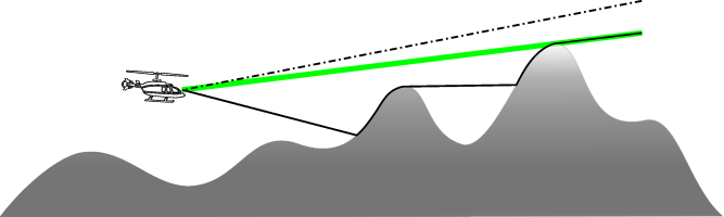
Computes the minimal heights from which one is visible around the center point of a line-of-sight
coverage with the sky as background. These heights are assigned along the given azimuth and stored
in the polar matrix view. This implementation takes the whole horizon of the line-of-sight coverage
into account while checking for terrain background. If this horizon is too close, the results will
be incorrect since terrain background just outside the horizon are not taken into account.
This propagation function needs an
ILcdLOSPropagationFunction on which it will base its
line-of-sight computations. The radar propagation function computes the minimal heights from which
one is visible. The visibility with sky in background is computed using the resulting value of the
last matrix entry corresponding to the given azimuth.
The matrix resulting from this propagation function can contain the following special values:
ILcdLOSRadarPropagationFunction.INVISIBLE: for points where the object is invisible.ILcdLOSRadarPropagationFunction.UNKNOWN: for points where the visibility is unknown. For example when no elevation data or invalid data was found at that point.
-
Field Summary
Fields inherited from interface com.luciad.tea.ILcdLOSRadarPropagationFunction
INVISIBLE, UNKNOWN -
Constructor Summary
ConstructorsConstructorDescriptionTLcdLOSRadarPropagationFunctionSkyBackground(ILcdLOSRadarPropagationFunction aLOSRadarPropagationFunction, TLcdCoverageAltitudeMode aAltitudeMode) Creates a propagation function which computes the minimal height from which one is visible from the center point of a circular area with the sky as background.TLcdLOSRadarPropagationFunctionSkyBackground(ILcdLOSRadarPropagationFunction aLOSRadarPropagationFunction, TLcdCoverageAltitudeMode aAltitudeMode, TLcdLOSOptions aLOSOption) Creates a propagation function which computes the minimal height from which one is visible from the center point of a circular area with the sky as background. -
Method Summary
Modifier and TypeMethodDescriptionvoidapplyForAzimuthSFCT(double aAzimuth, ILcdLOSCoverageMatrix aLOSCoverageMatrixSFCT) Computes the minimal heights from which one is visible around the center point of a line-of-sight coverage with the sky as background for a given azimuth and stores the resulting heights in the line-of-sight coverage matrix.createLOSCoverageMatrix(ILcdLOSCoverage aLOSCoverage, ILcdGeoReference aMatrixReference) Creates a coverage matrix using the line-of-sight coverageaLOSCoverageand the matrix referenceaMatrixReference.Returns the altitude mode indicating the definition of the resulting line-of-sight values.Returns the earth representation mode used by this instance.doubleReturns the K-factor indicating the reflection of radar waves on the atmosphere.doubleReturns the maximum radar tilt angle in degrees, starting from 0 at the horizontal plane to 90 at zenith.doubleReturns the azimuth in degrees where the maximum radar tilt angle occurs.doubleReturns the maximum angle of the vertical extent in degrees, starting from 0 at the ground to 180 at zenith.doubleReturns the minimum angle of the vertical extent in degrees, starting from 0 at the ground to 180 at zenith.Returns the elevation provider used to retrieve the terrain elevation data.voidinitialize(ILcdLOSCoverage aLOSCoverage, ILcdGeoReference aMatrixReference) Initialize the propagation function with the given coverageaLOSCoverageand the given matrix referenceaMatrixReference.
-
Constructor Details
-
TLcdLOSRadarPropagationFunctionSkyBackground
public TLcdLOSRadarPropagationFunctionSkyBackground(ILcdLOSRadarPropagationFunction aLOSRadarPropagationFunction, TLcdCoverageAltitudeMode aAltitudeMode) Creates a propagation function which computes the minimal height from which one is visible from the center point of a circular area with the sky as background. Note that the propagation function cannot be set tonull. If this condition is not met, aNullPointerExceptionwill be thrown.- Parameters:
aLOSRadarPropagationFunction- The propagation function on which to base its computations.aAltitudeMode- The altitude mode indicating the definition of the resulting values.- Throws:
NullPointerException- when the argumentaLOSRadarPropagationFunctionisnull.IllegalArgumentException-- if the argument
aLOSRadarPropagationFunctiondoes not use the following earth representation mode:TLcdEarthRepresentationMode.SPHERICAL_FIXED_RADIUSorTLcdEarthRepresentationMode.SPHERICAL_EULER_RADIUSor if it uses the altitude modeTLcdCoverageAltitudeMode.ABOVE_OBJECT, - if the
aAltitudeModeisTLcdCoverageAltitudeMode.ABOVE_OBJECTand - if the argument
aKFactoris smaller than or equal to zero.
- if the argument
-
TLcdLOSRadarPropagationFunctionSkyBackground
public TLcdLOSRadarPropagationFunctionSkyBackground(ILcdLOSRadarPropagationFunction aLOSRadarPropagationFunction, TLcdCoverageAltitudeMode aAltitudeMode, TLcdLOSOptions aLOSOption) Creates a propagation function which computes the minimal height from which one is visible from the center point of a circular area with the sky as background. Note that the propagation function cannot be set tonull. If this condition is not met, aNullPointerExceptionwill be thrown.- Parameters:
aLOSRadarPropagationFunction- The propagation function on which to base its computations.aAltitudeMode- The altitude mode indicating the definition of the resulting values.aLOSOption- A LOS option object containing parameters for the internals of this propagation function and its resulting coverages- Throws:
NullPointerException- when the argumentaLOSRadarPropagationFunctionisnull.IllegalArgumentException-- if the argument
aLOSRadarPropagationFunctiondoes not use the following earth representation mode:TLcdEarthRepresentationMode.SPHERICAL_FIXED_RADIUSorTLcdEarthRepresentationMode.SPHERICAL_EULER_RADIUSor if it uses the altitude modeTLcdCoverageAltitudeMode.ABOVE_OBJECT, - if the
aAltitudeModeisTLcdCoverageAltitudeMode.ABOVE_OBJECTand - if the argument
aKFactoris smaller than or equal to zero.
- if the argument
-
-
Method Details
-
createLOSCoverageMatrix
public ILcdLOSCoverageMatrix createLOSCoverageMatrix(ILcdLOSCoverage aLOSCoverage, ILcdGeoReference aMatrixReference) Description copied from interface:ILcdLOSPropagationFunctionCreates a coverage matrix using the line-of-sight coverageaLOSCoverageand the matrix referenceaMatrixReference. The result of this method is used as input parameter for the methodapplyForAzimuthSFCT, which will store the actual matrix values. The matrix should be consistent with the given coverage. This means that all matrix rows and columns represent evenly spaced radii and azimuths as defined by the radial and angular step sizes of the line-of-sight coverage. The methodILcdLOSPropagationFunction.initialize(com.luciad.tea.ILcdLOSCoverage, com.luciad.reference.ILcdGeoReference)is called with the same arguments as supplied with this method.The
ILcdLOSCoverageMatrixcreated by this method is guaranteed to be capable of determining its own associatedPointX and associatedPointY properties. These values are not calculated by thisILcdPropagationFunction. AnILcdLOSPropagationFunctiondoes not modify the values of the associatedPointX and associatedPointY for its createdILcdLOSCoverageMatrix.- Specified by:
createLOSCoverageMatrixin interfaceILcdLOSPropagationFunction- Parameters:
aLOSCoverage- The covered area and the intermediate step sizes.aMatrixReference- The reference in which this matrix is defined.- Returns:
- the created coverage matrix.
-
initialize
Description copied from interface:ILcdLOSPropagationFunctionInitialize the propagation function with the given coverageaLOSCoverageand the given matrix referenceaMatrixReference. For performance reasons, it is recommended that this method initializes all fields that are common to all computations or which do not depend on a specific azimuth.- Specified by:
initializein interfaceILcdLOSPropagationFunction- Parameters:
aLOSCoverage- The covered area to use.aMatrixReference- The matrix reference in which to compute the matrix values.
-
applyForAzimuthSFCT
Computes the minimal heights from which one is visible around the center point of a line-of-sight coverage with the sky as background for a given azimuth and stores the resulting heights in the line-of-sight coverage matrix. Note that this implementation assumes that the default value of a matrix entry corresponds to the value for invisible points (which isILcdLOSRadarPropagationFunction.INVISIBLE). Refer to the class documentation for more information about the different special values.- Specified by:
applyForAzimuthSFCTin interfaceILcdLOSPropagationFunction- Parameters:
aAzimuth- The azimuth in degrees.aLOSCoverageMatrixSFCT- The coverage matrix to update.- Throws:
NullPointerException- if the aLOSCoverageMatrixSFCT isnull.
-
getEarthRepresentationMode
Description copied from interface:ILcdLOSRadarPropagationFunctionReturns the earth representation mode used by this instance.- Specified by:
getEarthRepresentationModein interfaceILcdLOSRadarPropagationFunction- Returns:
- the earth representation mode used by this instance.
-
getAltitudeMode
Description copied from interface:ILcdLOSRadarPropagationFunctionReturns the altitude mode indicating the definition of the resulting line-of-sight values.- Specified by:
getAltitudeModein interfaceILcdLOSRadarPropagationFunction- Returns:
- the altitude mode indicating the definition of the resulting line-of-sight values.
-
getKFactor
public double getKFactor()Description copied from interface:ILcdLOSRadarPropagationFunctionReturns the K-factor indicating the reflection of radar waves on the atmosphere. For radar computations, values should be greater than 1, usually 4/3. Setting the value equal to 1 will yield the same results as visual line-of-sight computations.- Specified by:
getKFactorin interfaceILcdLOSRadarPropagationFunction- Returns:
- the K-factor indicating the reflection of radar waves on the atmosphere.
-
getMaxVerticalAngle
public double getMaxVerticalAngle()Description copied from interface:ILcdLOSRadarPropagationFunctionReturns the maximum angle of the vertical extent in degrees, starting from 0 at the ground to 180 at zenith. It is the maximum vertical angle when the radar tilt angle is set to zero.- Specified by:
getMaxVerticalAnglein interfaceILcdLOSRadarPropagationFunction- Returns:
- the maximum angle of the vertical extent in degrees.
-
getMinVerticalAngle
public double getMinVerticalAngle()Description copied from interface:ILcdLOSRadarPropagationFunctionReturns the minimum angle of the vertical extent in degrees, starting from 0 at the ground to 180 at zenith. It is the minimum vertical angle when the radar tilt angle is set to zero.- Specified by:
getMinVerticalAnglein interfaceILcdLOSRadarPropagationFunction- Returns:
- the minimum angle of the vertical extent in degrees.
-
getMaxRadarTiltAngle
public double getMaxRadarTiltAngle()Description copied from interface:ILcdLOSRadarPropagationFunctionReturns the maximum radar tilt angle in degrees, starting from 0 at the horizontal plane to 90 at zenith.- Specified by:
getMaxRadarTiltAnglein interfaceILcdLOSRadarPropagationFunction- Returns:
- the maximum radar tilt angle in degrees.
-
getMaxRadarTiltAzimuth
public double getMaxRadarTiltAzimuth()Description copied from interface:ILcdLOSRadarPropagationFunctionReturns the azimuth in degrees where the maximum radar tilt angle occurs.- Specified by:
getMaxRadarTiltAzimuthin interfaceILcdLOSRadarPropagationFunction- Returns:
- the azimuth in degrees where the maximum radar tilt angle occurs.
-
getTerrainElevationProvider
Description copied from interface:ILcdLOSRadarPropagationFunctionReturns the elevation provider used to retrieve the terrain elevation data.- Specified by:
getTerrainElevationProviderin interfaceILcdLOSRadarPropagationFunction- Returns:
- the elevation provider used to retrieve the terrain elevation data.
-