Package com.luciad.projection
Class TLcdGeneralPerspective
java.lang.Object
com.luciad.projection.ALcdProjection
com.luciad.projection.ALcdGeneralPerspective
com.luciad.projection.TLcdGeneralPerspective
- All Implemented Interfaces:
ILcdGeneralPerspective,ILcdProjection,ILcdPropertyChangeSource,Serializable,Cloneable
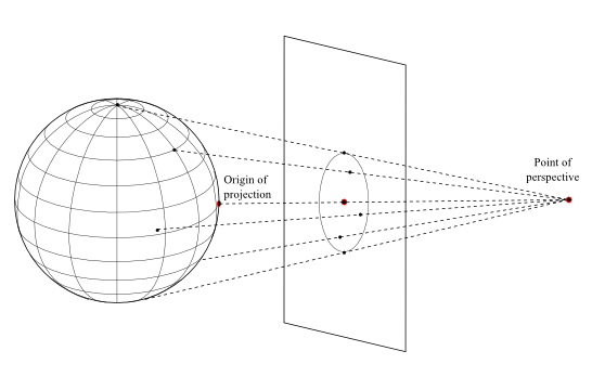
General perspective projection.
Introduction
The general perspective projection is an azimuthal projection using the origin of projection and the point of perspective. The origin height is taken into account. It is possible to tilt the projection plane.
Properties
- The central meridian and a particular parallel (if shown) are projected as straight lines.
- Other meridians and parallels are usually arcs of circles or ellipses, but some may be parabolas or hyperbolas.
- Neither conformal (unless Stereographic), nor equal-area.
- If the point of perspective is above the center of the sphere or ellipsoid, les than one hemisphere may be shown (unless Orthographic).
- If the point of perspective is below the center of the globe, more than one hemisphere may be shown (cfr. Stereographic).
- There is considarable distortion near the projection limit.
Example
Sample code
 ILcdProjection projection =
     new TLcdGeneralPerspective(40.0, -100.0, 0.0, 2.0, 0.0, 0.0);
Implementation aspects
The equations of the general perspective projection are taken from [Snyder1987].
Note
The point of perspective has to be outside the earth ellipsoid. So, its value should be outside the closed interval [-1.0,1.0].
- See Also:
-
Field Summary
Fields inherited from class com.luciad.projection.ALcdProjection
fPropertyChangeDispatcherFields inherited from interface com.luciad.projection.ILcdProjection
EPSILON -
Constructor Summary
ConstructorsConstructorDescriptionConstructs a general perspective projection with the origin at point(0.0, 0.0, 0.0), the perspective distance at 2.0, the azimuth set to 0.0, and the tilt set to 0.0.TLcdGeneralPerspective(double aLongitude, double aLatitude, double aHeight, double aPerspectiveDistance, double aAzimuth, double aTiltAngle) Constructs a general perspective projection with the origin at a point(aLatitude, aLongitude, aHeight).TLcdGeneralPerspective(ILcdPoint aOrigin, double aPerspectiveDistance) Constructs a general perspective projection with the origin at anILcdPointaOriginand a point of perspective at a distance (divided by the semi-major axis) from the center of the earth.TLcdGeneralPerspective(ILcdPoint aOrigin, double aPerspectiveDistance, double aAzimuth, double aTiltAngle) Constructs a general perspective projection with the origin at anILcdPointaOriginand a point of perspective at a distance (divided by the semi-major axis) from the center of the earth. -
Method Summary
Modifier and TypeMethodDescriptiondouble[][]boundaryLats(double lon) Default implementation.double[][]boundaryLons(double lat) Default implementation.protected voidConstants based on the longitude, latitude, height of the point of origin of projection and the distance of the point of perspective don't have to be recalculated every time a method is called.clone()Makes a deep clone of thisILcdProjection.booleaninLonLatBounds(ILcdPoint aLLP) Checks if anILcdPointis inside the valid area of geodetic coordinates of the projection.booleaninWorldBoundsOnSphere(ILcdPoint aXYPoint, double aRadius) Checks if aILcdPointis inside the valid cartesian area of the projection.booleanIf all geodetic coordinates (l ,j ) are projected (visible) by anILcdProjectionand all (x,y ) coordinates are bounded this istrue.voidlonlatheight2worldOnEllipsoidSFCT(ILcdPoint aLLHP, ILcdEllipsoid aEllipsoid, ILcd2DEditablePoint aWorldPoint) Default implementation callslonlatheight2worldOnEllipsoidSFCTwithaEllipsoid.getAuxRadius()as sphere radius.voidlonlatheight2worldOnSphereSFCT(ILcdPoint aLLHP, double aRadius, ILcd2DEditablePoint aWorldPoint) Transforms anILcd2DEditablePointon a sphere into the cartesian coordinate system of the projection.toString()Returns theStringrepresentation of the general perspective projection.voidworld2DEditableBoundsOnSphereSFCT(double aRadius, ILcd2DEditableBounds aWorldBound) The projection is bounded when the perspective distance is outside the closed interval [-1,1].voidworld2lonlatOnEllipsoidSFCT(ILcdPoint aXYPoint, ILcdEllipsoid aEllipsoid, ILcd2DEditablePoint aLLPSFCT) Transforms a world point to a LonLatHeightPoint.voidworld2lonlatOnSphereSFCT(ILcdPoint aXYPoint, double aRadius, ILcd2DEditablePoint aLLPSFCT) Transforms anILcdPointfrom the cartesian coordinate system of the projection into anILcd2DEditablePointonto a sphere.Methods inherited from class com.luciad.projection.ALcdGeneralPerspective
equals, getAzimuth, getOrigin, getOriginHeight, getOriginLat, getOriginLon, getPerspectiveDistance, getTilt, hashCode, isContinuous, loadProperties, setAzimuth, setOriginHeight, setOriginLat, setOriginLon, setPerspectiveDistance, setTilt, writePropertiesSFCTMethods inherited from class com.luciad.projection.ALcdProjection
addPropertyChangeListener, firePropertyChangeEvent, inWorldBoundsOnEllipsoid, removePropertyChangeListener, world2DEditableBoundsOnEllipsoidSFCTMethods inherited from class java.lang.Object
finalize, getClass, notify, notifyAll, wait, wait, waitMethods inherited from interface com.luciad.projection.ILcdProjection
inWorldBoundsOnEllipsoid, world2DEditableBoundsOnEllipsoidSFCTMethods inherited from interface com.luciad.util.ILcdPropertyChangeSource
addPropertyChangeListener, removePropertyChangeListener
-
Constructor Details
-
TLcdGeneralPerspective
public TLcdGeneralPerspective()Constructs a general perspective projection with the origin at point(0.0, 0.0, 0.0), the perspective distance at 2.0, the azimuth set to 0.0, and the tilt set to 0.0. -
TLcdGeneralPerspective
public TLcdGeneralPerspective(double aLongitude, double aLatitude, double aHeight, double aPerspectiveDistance, double aAzimuth, double aTiltAngle) Constructs a general perspective projection with the origin at a point(aLatitude, aLongitude, aHeight).- Parameters:
aLongitude- longitude of the origin of the projection, in decimal degrees.aLatitude- latitude of the origin of the projection, in decimal degrees.aHeight- height of the origin point above the ellipsoid.aPerspectiveDistance- distance of the point of perspective from the center of the earth globe divided by the semi-major axis.aAzimuth- azimuth east of north of the Y-axis of the Y_t axis of the tilted plane of projectionaTiltAngle- upward angle of tilt, or the angle between the Y_t axis and the tangent plane, expressed in degrees
-
TLcdGeneralPerspective
Constructs a general perspective projection with the origin at anILcdPointaOriginand a point of perspective at a distance (divided by the semi-major axis) from the center of the earth. The properties azimuth and tiltAngle are set to zero.- Parameters:
aOrigin- point of origin (3D) of the projection.aPerspectiveDistance- distance of the point of perspective from the center of the earth globe divided by the semi-major axis.
-
TLcdGeneralPerspective
public TLcdGeneralPerspective(ILcdPoint aOrigin, double aPerspectiveDistance, double aAzimuth, double aTiltAngle) Constructs a general perspective projection with the origin at anILcdPointaOriginand a point of perspective at a distance (divided by the semi-major axis) from the center of the earth.- Parameters:
aOrigin- point of origin (3D) of the projection.aPerspectiveDistance- distance of the point of perspective from the center of the earth globe divided by the semi-major axis.aAzimuth- azimuth east of north of the Y-axis of the Y_t axis of the tilted plane of projectionaTiltAngle- upward angle of tilt, or the angle between the Y_t axis and the tangent plane, expressed in degrees
-
-
Method Details
-
calculateCachedValues
protected void calculateCachedValues()Description copied from class:ALcdGeneralPerspectiveConstants based on the longitude, latitude, height of the point of origin of projection and the distance of the point of perspective don't have to be recalculated every time a method is called. They only have to be calculated when the projection properties change. Within the methods the precalculated values then can be used in order to gain efficiency.- Overrides:
calculateCachedValuesin classALcdGeneralPerspective
-
isAllInBounds
public boolean isAllInBounds()Description copied from interface:ILcdProjectionIf all geodetic coordinates (l ,j ) are projected (visible) by anILcdProjectionand all (x,y ) coordinates are bounded this istrue. AllILcdProjectionobjects have bounded (x,y ) coordinates because the projection is cut off if necessary.- Returns:
trueif all LonLatPoints are within the bounds of the projection,falseotherwise.
-
lonlatheight2worldOnSphereSFCT
public void lonlatheight2worldOnSphereSFCT(ILcdPoint aLLHP, double aRadius, ILcd2DEditablePoint aWorldPoint) throws TLcdOutOfBoundsException Description copied from interface:ILcdProjectionTransforms anILcd2DEditablePointon a sphere into the cartesian coordinate system of the projection.- Parameters:
aLLHP- point to be projected.aRadius- radius of the sphere (meters).aWorldPoint- projected point as side effect.- Throws:
TLcdOutOfBoundsException- If theILcdPointaLLHPis not within the valid area of the projection (visible area), then this exception is thrown.
-
lonlatheight2worldOnEllipsoidSFCT
public void lonlatheight2worldOnEllipsoidSFCT(ILcdPoint aLLHP, ILcdEllipsoid aEllipsoid, ILcd2DEditablePoint aWorldPoint) throws TLcdOutOfBoundsException Description copied from class:ALcdProjectionDefault implementation callslonlatheight2worldOnEllipsoidSFCTwithaEllipsoid.getAuxRadius()as sphere radius.- Specified by:
lonlatheight2worldOnEllipsoidSFCTin interfaceILcdProjection- Overrides:
lonlatheight2worldOnEllipsoidSFCTin classALcdProjection- Parameters:
aLLHP- point to be projected.aEllipsoid- ellipsoid on which the point is defined.aWorldPoint- projected point as side effect.- Throws:
TLcdOutOfBoundsException- If theILcdPointaLLHPis not within the valid area of the projection (visible area), then this exception is thrown.
-
world2lonlatOnSphereSFCT
public void world2lonlatOnSphereSFCT(ILcdPoint aXYPoint, double aRadius, ILcd2DEditablePoint aLLPSFCT) throws TLcdOutOfBoundsException Description copied from interface:ILcdProjectionTransforms anILcdPointfrom the cartesian coordinate system of the projection into anILcd2DEditablePointonto a sphere.- Parameters:
aXYPoint- projected point for which the corresponding geodetic point is sought.aRadius- radius of the sphere (meters).aLLPSFCT- resulting geodetic coordinate as side effect.- Throws:
TLcdOutOfBoundsException- If theILcdPointaXYPointis not within the valid area of the projection (visible area), then this exception is thrown.
-
world2lonlatOnEllipsoidSFCT
public void world2lonlatOnEllipsoidSFCT(ILcdPoint aXYPoint, ILcdEllipsoid aEllipsoid, ILcd2DEditablePoint aLLPSFCT) throws TLcdOutOfBoundsException Transforms a world point to a LonLatHeightPoint. The height, which is taken into account, is supposed to be available in the input/output parameteraLLPSFCT.- Specified by:
world2lonlatOnEllipsoidSFCTin interfaceILcdProjection- Overrides:
world2lonlatOnEllipsoidSFCTin classALcdProjection- Parameters:
aXYPoint- projected point for which the corresponding geodetic point is sought.aEllipsoid- ellipsoid on which the geodetic coordinate is defined.aLLPSFCT- resulting geodetic coordinate as side effect.- Throws:
TLcdOutOfBoundsException- If theILcdPointaXYPointis not within the valid area of the projection (visible area), then this exception is thrown.
-
inLonLatBounds
Description copied from interface:ILcdProjectionChecks if anILcdPointis inside the valid area of geodetic coordinates of the projection. The valid area is determined by the LonLatPoints that are visible and for which the corresponding cartesian coordinate is within the boundaries.- Parameters:
aLLP-ILcdPointto be checked upon.- Returns:
trueif valid,falseif invalid.
-
boundaryLons
public double[][] boundaryLons(double lat) Description copied from class:ALcdProjectionDefault implementation. To be redefined for specific projections.- Specified by:
boundaryLonsin interfaceILcdProjection- Overrides:
boundaryLonsin classALcdProjection- Parameters:
lat- latitude in decimal degrees and -90.0 <=aLat<= 90.0.- Returns:
- the array of pairs of longitudes[0] and longitudes[1], where the closed interval longitudes[0] -> longitudes[1] is in visible area and -180.0 <= lon[i] <= 180.0.
-
boundaryLats
public double[][] boundaryLats(double lon) Description copied from class:ALcdProjectionDefault implementation. To be redefined for specific projections.- Specified by:
boundaryLatsin interfaceILcdProjection- Overrides:
boundaryLatsin classALcdProjection- Parameters:
lon- longitude in decimal degrees -180.0 <= lon <= 180.0 .- Returns:
- the array of pairs of latitudes lats[0] and lats[1], where the closed interval lats[0] -> lats[1] is in visible area and -90.0 <= lats[i] <= 90.0 .
-
world2DEditableBoundsOnSphereSFCT
The projection is bounded when the perspective distance is outside the closed interval [-1,1]. Currently a perspective distance within this closed interval [-1,1] is not supported.- Parameters:
aRadius- radius of the sphere.aWorldBound- the bounds of the projection in world coordinates as side effect.
-
inWorldBoundsOnSphere
Description copied from interface:ILcdProjectionChecks if aILcdPointis inside the valid cartesian area of the projection. The valid cartesian area is determined naturally by the projection bounds or by an artificial introduced boundary limit because some cartesian points are at infinity. The shape of the valid cartesian area is in many cases rectangular or circular although it might be more complex.- Parameters:
aXYPoint- point to be checked upon.aRadius- radius of the sphere.- Returns:
trueif valid,falseif invalid.
-
toString
Returns theStringrepresentation of the general perspective projection.- Specified by:
toStringin interfaceILcdProjection- Overrides:
toStringin classObject- Returns:
- the
Stringrepresentation of the general perspective projection.
-
clone
Description copied from interface:ILcdProjectionMakes a deep clone of thisILcdProjection.- Specified by:
clonein interfaceILcdProjection- Overrides:
clonein classALcdGeneralPerspective- Returns:
- deep clone of this
ILcdProjection.
-