LuciadLightspeed coordinate reference systems
A coordinate reference system (CRS) specifies the coordinate system that is used to define locations on the Earth or on a flat surface representing the Earth. Based on this definition, there are two types of CRSes:
-
Geodetic reference systems (
ILcdGeodeticReference) that represent geographic locations on an ellipsoidal (or a spherical) surface using longitude and latitude coordinates. Geodetic reference systems are based on an ellipsoid that approximates the shape of the earth. A commonly used geodetic reference system is the World Geodetic System 1984 (WGS 1984). -
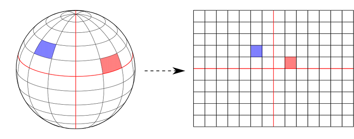
Cartesian or grid reference systems (
ILcdGridReference) that represent geographic locations on a flat surface using x and y coordinates. A Cartesian reference system is usually based on a geodetic reference system and requires a map projection to represent the curved surface of the earth on a flat surface as shown in Figure 1, “Projecting the Earth’s surface to a flat surface”.

Each CRS is associated with a geodetic datum (ILcdGeodeticDatum). A geodetic datum typically defines an ellipsoid and its position in relation to the Earth. The ellipsoid’s position is
specified by linking the ellipsoid to a number of physical points on the surface of the Earth. Alternatively, the ellipsoid’s
position can be specified by means of a translation and a rotation relative to a known geodetic datum, for example the one
used by the WGS 1984.
Refer to the API reference for more details on ILcdGeodeticReference and ILcdGridReference and their implementations. Model, world, and view coordinates introduces the model, view, and world coordinate systems and the relationships between them.
Model, world, and view coordinates
The position of the model data is defined at three different levels in LuciadLightspeed using:
-
Model coordinates defined within a coordinate system determined by the model reference. The model reference (
ILcdModelReference), or CRS associated with anILcdModel, usually is anILcdGeodeticReferenceorILcdGridReference. -
World coordinates defined within a coordinate system determined by the world reference. The world reference (
ILcdXYZWorldReference), or CRS associated with anILspView, usually is anILcdGridReferencefor 2D or anILcdGeocentricReferencefor 3D. For anILcdGXYView, the associated world reference (ILcdXYWorldReference) usually is anILcdGridReference. -
View coordinates defined by the 2D screen coordinates (or pixel coordinates).
Both the world and the view coordinate systems are associated with an ILspView or an ILcdGXYView. The world level is an intermediate level between the model and the view, which is used internally in the ILspView and ILcdGXYView, mainly for performance reasons. One of the benefits of LuciadLightspeed is that the model references of your data can differ
from each other and from the world reference. LuciadLightspeed automatically converts the model data to the world reference.
All model data is displayed in the same reference system in the view and you do not need to transform any data yourself.