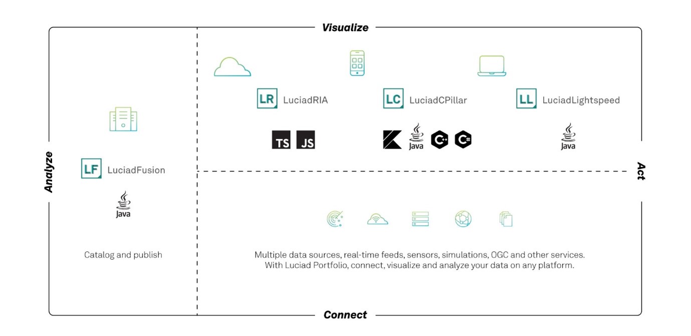
The products in the Luciad portfolio provide software components for building state-of-the-art geospatial software solutions. Figure 1, “The product diagram” shows a schematic overview of the products and the targeted environments. Each product can be used on its own, but you can also use several products in combination. A common denominator between the products is the application of the Model-View-Controller (MVC) design pattern, resulting in a higher code flexibility and re-usability.
Desktop, Browser and Mobile
The products LuciadLightspeed and LuciadCPillar provide the foundations for the development of geospatial applications for desktops, including Linux, Windows and MacOS. LuciadLightspeed targets the Java developer ecosystem, while LuciadCPillar targets C++/C#. In addition, LuciadCPillar focuses on mobile devices, with its support for mobile application development in Java and Kotlin on the Android platform. LuciadLightspeed also includes Lucy, a Java Swing-based application framework that integrates much of the functionality from the LuciadLightspeed API. It is designed specifically to support rapid application development.
LuciadRIA is a JavaScript and TypeScript API designed to build geospatial applications that run in browsers. Because they are based on JavaScript, they do not require any browser plugin to run. LuciadRIA takes advantage of HTML5 and WebGL technology to offer a rich web application experience with the possibility to benefit from hardware acceleration.
All three products allow, among many other things, to:
-
Connect to a variety of data sources
-
Visualize data on the map
-
Interact with the data and the map: navigate, select, edit, and so on
-
Perform visual analytics on the data
|
The Desktop, Browser and Mobile products are APIs allowing developers to build their own application. None of them are finished end user products. |
Server
LuciadFusion is an all-in-one server solution for geospatial data management and data publication. Highlights include capabilities to serve geospatial data to applications using standardized protocols (such as OGC WMS, WFS, and WCS) and the processing and fusion of large volumes of data for efficient access and exchange, for instance, the combination of multiple LIDAR point clouds of data into one coherent, optimized data set.
The product comes with two end user applications:
-
LuciadFusion Studio: a web application to manage your geospatial data and publish it through web services.
-
Data Connectivity Manager: a GUI desktop tool to process, combine and tile massive raster and elevation data sets so that the data can be efficiently accessed by geospatial applications.
It also includes an extensive set of REST and Java APIs:
-
A REST API for LuciadFusion Studio, allowing you to automate your data management and publication.
-
A tiling engine API, allowing you to automate the functionality provided by the Data Connectivity Manager.
-
API to customize LuciadFusion Studio, such as integrating custom styling logic, custom data format support, and so on.
-
API to create your own OGC web services without the need to use LuciadFusion Studio.
-
API of components shared with LuciadLightspeed, such as terrain analysis, geometry calculations, routing, and so on.