What is the OGC Web Server Suite?
With the OGC Web server suite, Luciad offers servers for several Open Geospatial Consortium (OGC) protocols. These are standards for querying and manipulating geospatial data based on various spatial and non-spatial constraints. For example:
-
Luciad Web Map Service (WMS) server: implements the OGC web service interface standard for the retrieval of geospatial maps in an image format.
-
Luciad Web Coverage Service (WCS) server: implements the OGC web service interface standard for the retrieval of coverages. Coverages are thematic data collections about phenomena that vary in space, such as demographic or weather information.
-
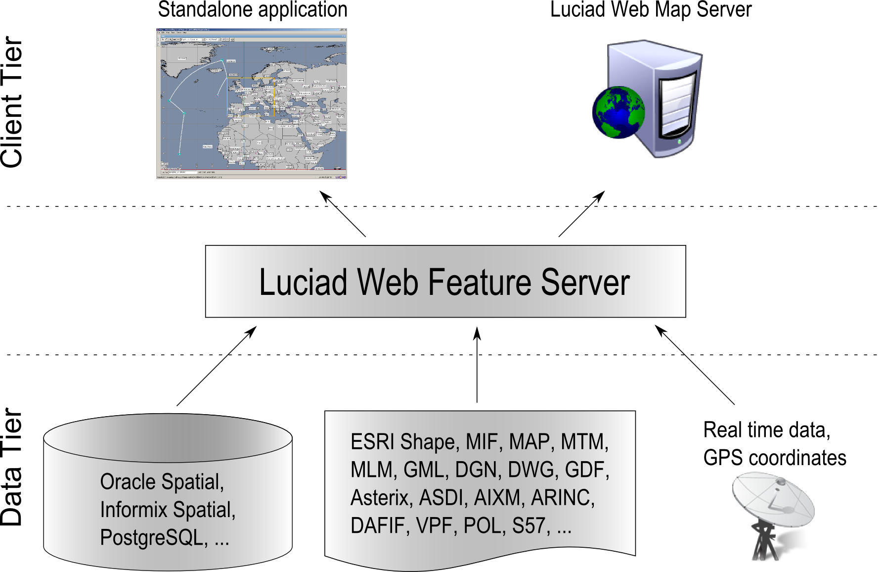
Luciad Web Feature Service (WFS) server: implements the OGC web service interface standard for the retrieval and manipulation of geospatial features.
-
Luciad Catalog Service for the Web (CSW) server: implements the OGC web service interface standard for the retrieval of metadata records.
In a typical scenario, clients contact the server for information about its capabilities: information about the data it offers, and in which formats. At this point, clients can either request more information, or they can create a request for the geospatial data if the returned capabilities match the requirements. When the server receives a request, it will return the requested data.
Basic architecture
The web service architecture has three main components:
-
A client which uses the server to query geographical data.
-
The Luciad server which retrieves the data from different data sources and distributes it to the client in an agreed data exchange format.
-
The data sources from which the server retrieves the data. This can be any data source for which a model decoder is available.
The Luciad OGC Web Server suite provides server samples based on LuciadLightspeed technology. They are fully functional and OGC-compliant servers. The API that goes with the suite allows users to further extend these servers by:
-
Plugging in additional standard LuciadLightspeed decoders for accessing data sources in any data type, and making their data available through the server. These can be LuciadLightspeed decoders provided in LuciadLightspeed or in any LuciadLightspeed component , or the user’s custom decoders.
-
Plugging in specific data exchange formats. The WFS server, for example, uses GML as the default exchange format with clients. Other output formats can be used as well, by plugging in an encoder for the format. These can be LuciadLightspeed encoders provided in LuciadLightspeed or in any LuciadLightspeed component, or the user’s custom encoders. To illustrate this, the WFS server sample plugs in the LuciadLightspeed encoder for the GeoJSON format.
-
Extending the OGC specification with custom requests or custom parameters, and implement the extended specification using the LuciadLightspeed Server APIs.
In addition, the WMS Server API allows you to:
-
Plug in specific output projections.
-
Plug in specific painters and label painters for providing a fully customized visual representation of the data.
Note that the decoders, projections, image encoders, and so on, used to extend the Luciad server,are standard LuciadLightspeed components. This means that they can be reused from and shared with existing LuciadLightspeed client applications.
What is the Luciad WFS server?
The OGC WFS specification defines a standard interface for querying and manipulating geographic data. The queries you formulate can be based on various spatial and non-spatial constraints, as defined by the OGC Filter specification.
You can find the Web Feature Service specification at http://www.opengeospatial.org/standards/wfs.
Typically, a WFS client starts querying a WFS server to know which geographic features are offered. This type of request is
called
the GetCapabilities request. Based on the returned information, the client can decide to retrieve more information
about a feature or to request a feature. The DescribeFeatureType request gives a full description of one or more geographic features served by the WFS.
The GetFeature request allows to retrieve a geographic feature in a known format. Next to these requests, a set of optional operations are
defined that allow a WFS to service transaction requests. A transaction request can be used to create, update or delete geographic
features.
The WFS specification uses GML, another OGC standard, as the default exchange format for geographic features. A Web Feature Service provides geographic information in a rich format, without any prior interpretation or rendering, and with full georeferencing. This contrasts with the WMS interface, which renders maps on the server side and returns simple images to the client.
The Luciad WFS server offers support for version 1.0.0, 1.1.0 and 2.0.0 of the transactional WFS (WFS-T) specification, and is certified OGC compliant.