The main goal of LuciadFusion is to make managing and serving geospatial data easy. End users can easily access and readily visualize the data served by LuciadFusion in 2D and 3D on clients running LuciadLightspeed or other OGC-compatible applications.
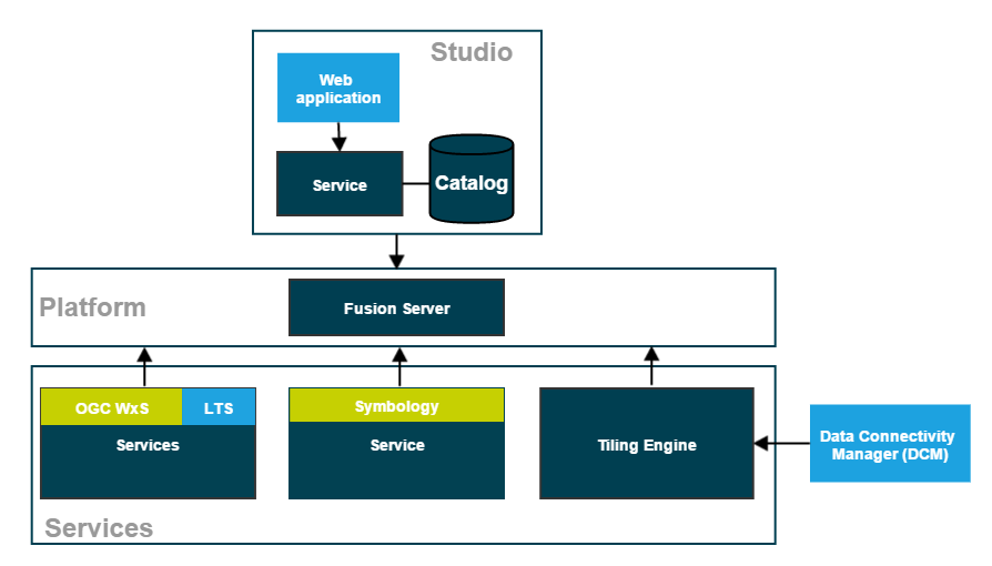
The foundation of LuciadFusion is provided by the LuciadFusion Platform, a service application framework. It consists of the LuciadFusion Server and allows you to plug in custom services. It also offers data publication services out of the box, as well as other tools and services that facilitate data management and publication.
The LuciadFusion Studio
Data managers can turn to LuciadFusion Studio to manage geospatial data and serve it to client applications. LuciadFusion Studio is a web application that allows data managers to centralize their geospatial data in a catalog, manage and style their data, and publish the resulting products through the services hosted on the LuciadFusion Platform.
Managing data centrally
The LuciadFusion catalog describes the data or data series managed in LuciadFusion Studio. You get your data and data resources in LuciadFusion by uploading it, or by adding the location of the data as a data root, and letting LuciadFusion Studio discover the data by crawling the data root. LuciadFusion supports all data resources, including metadata and style files.
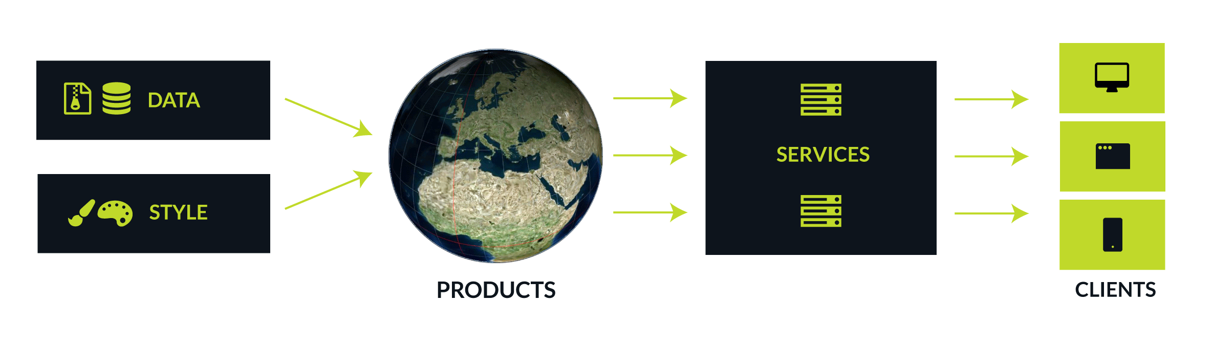
Once you have imported all data, LuciadFusion allows you to manage it centrally, create products from the data, and serve the data to client applications from services.
Publishing products
To serve your client applications an integral geospatial picture, you can combine several thematically related datasets into products, and publish that product through the LuciadFusion services. LuciadFusion products also allow you to style data differently according to client needs, by setting up several products that each combine the same data set with distinct style files.
More detailed information can be found in Geospatial data management and publication in LuciadFusion Studio
LuciadFusion Platform Services
The LuciadFusion Platform hosts multiple services that allow you to publish your data to any geospatial application through various OGC and custom protocols:
- Serve data on-the-fly through OGC WxS services
-
Direct publication of data through OGC services, without fusing it upfront. Data can be published on a number of services defined by the Open Geospatial Consortium. The supported OGC service protocols are:
-
The OGC Web Map Service lets you publish data with styling applied.
-
The OGC Web Map Tiling Service lets you publish data with styling applied. The styled data is served in a tiled fashion.
-
The OGC Web Feature Service lets you retrieve vector data.
-
The OGC Web Coverage Service lets you retrieve raster data.
-
- Serve fused/pre-tiled data
-
The process of fusing data consists of converting data into a new data set organized in a hierarchical tile structure, often called a coverage. The OGC 3D Tiles services automatically fuses 3D point cloud and mesh data without any interaction. The Tiling Engine is a service that can fuse vector and raster data on request. You can use the Data Connectivity Manager tool to configure the Tiling Engine.
| OGC 3D Tiles Service |
The OGC 3D Tiles service lets you publish a large amount of point cloud or mesh data using the 3D Tiles protocol. |
| Tiling Engine |
The Tiling Engine is a service that fuses source data to organize it in a hierarchical tile structure, a coverage. This optimizes access to the data, for the purpose of querying, visualization, and analysis. |
| Data Connectivity Manager (DCM) |
The DCM is a tool that allows you to connect to local or remote data sources, retrieve the data, fuse the data with the Tiling Engine, and store the fused data as coverages. |
| Tile Store |
A logical structure combining various coverages. You can use it in LuciadFusion V2016.1 and in the DCM, but not in the LuciadFusion Studio. |
| Luciad Tile Service(LTS) |
The Luciad Tile Service allows you to retrieve tiles that have been prepared using the Tiling Engine. |
- Serve panoramic image data through a service
-
The Panoramic Image Service (PANORAMICS) serves panoramic image data as multi-leveled, tiled cubemaps.
- Serve Hexagon Smart Point Cloud (HSPC) data through the HSPC service
-
The HSPC service serves tiled and multi-leveled point cloud data which can be loaded and visualized natively by LuciadRIA. HSPC is a proprietary Hexagon format, describing a 3D tiles hierarchy.
- Serve MBTiles data through a service
-
The MBTiles service serves tiled raster and vector data in the MBTiles format.
- Serve dataset files through a web service
-
Provide direct access to the individual files of your datasets.
- Serve metadata through an OGC catalog service
-
Provide access to the metadata of your datasets and services.
- Serve Symbology through a service
-
The Symbology Service serves MS2525/APP6 icons. This is an optional service. The extent of your license determines whether you can use this service.
- Serve ECW and JPEG2000 data through a service
-
The Enhanced Compressed Wavelet Protocol (ECWP) Service serves ECW and JPEG2000 data to ECWP clients. The ECW Protocol is a streaming protocol for sending ECW and JPEG2000 images over a network.
For each service type, except for the catalog and symbology services, you can create multiple instances, each hosting many products. You can set up two WMS services, for instance.
The LuciadFusion Platform is based on the well-known Spring framework for system and application development. Java developers familiar with the Spring framework can quickly familiarize themselves with the LuciadFusion Platform as well. They can also easily customize and extend the platform to suit the needs of their organization.
The LuciadFusion Platform also allows developers to add and remove services, customize services through configuration, and develop and plug in their own services, to perform additional data analysis for example.