The LuciadFusion Platform allows you to create WMS or WMTS services that are DGIWG-compliant in accordance with the following specifications:
By default, LuciadFusion already supports all the requirements in the specification, but you must still set all the service metadata needed for DGIWG compliance.
Setting the metadata
You can set the metadata when you create a WMS or WMTS service in LuciadFusion Studio. Figure 1, “Dialog to add metadata for a new WMS service” shows how you can complete the metadata in the Create Service dialog. LuciadFusion uses that metadata when it creates the GetCapabilities document for a WMS or WMTS service. The DGIWG specifications puts restrictions on the content of the GetCapabilities document and hence on the content of the metadata.
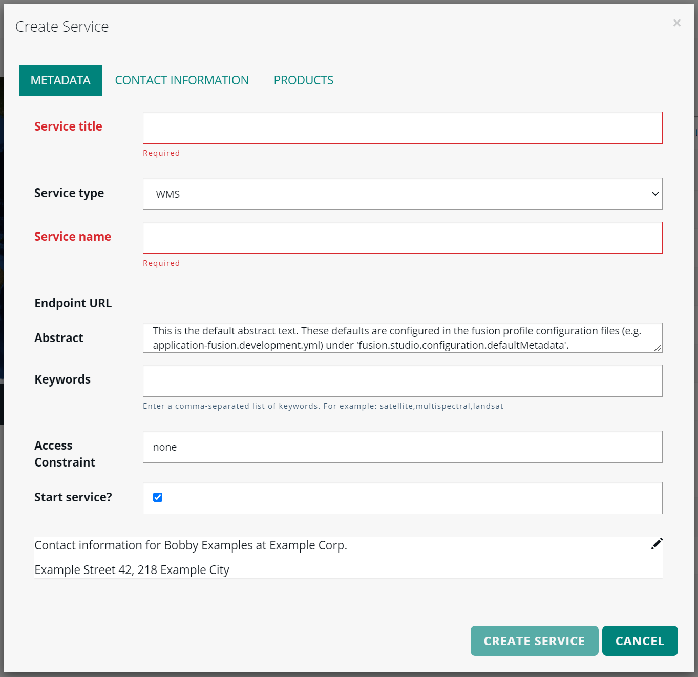
Setting the Abstract information
The WMS DGIWG specification has this requirement:
Requirement 26: A DGIWG Queryable WMS server shall include the following information in the abstract element of the service metadata:
"This service implements the DGIWG WMS 1.3 profile version 3.0, DGIWG Queryable WMS conformance class (http://www.dgiwg.org/std/wms/3.0/conf/queryable)."
The WMTS DGIWG specification has this requirement:
Requirement 17: A DGIWG WMTS server SHALL include the following information in the abstract element of the service metadata:
"This service implements the DGIWG WMTS profile version 1.0, DGIWG Queryable WMTS conformance class (URI) (http://www.dgiwg.org/std/wmts/1.0/conf/queryable)."
To comply with these requirements, set the abstract to these values when you create a DGIWG-compliant WMS or WMTS service.
Setting the keywords
The WMS DGIWG specification has this requirement:
A DGIWG Basic WMS server shall provide a minimum keyword list based on the DGIM (DGIWG Geospatial Information Model) groups.
See Annex F of this specification for more information about these groups.
The WMTS DGIWG specification has this requirement:
A DGIWG WMTS server SHALL have a minimum keyword list based on the Defence Geospatial Information Framework -2 (DGIF-2) Groupings.
See Annex C of this specification for more information about these groups.
Again, the user creating the WMS or WMTS service must set the keywords correctly to achieve DGIWG compliance.
Setting the access constraint
The WMS DGIWG specification has this requirement:
Requirement 8: If content provided by a WMS server is classified, a DGIWG Basic WMS server shall identify
the highest classification level of the content accessible through the WMS service by populating the wms:AccessConstraints element.
The valid classification levels depend on the context. For example, in a NATO environment, you must apply the common NATO classification scheme.
The WMTS DGIWG specification has this requirement:
A DGIWG WMTS server SHALL provide all service metadata elements based upon the DGIWG Metadata Foundation (DMF) v2.0.
The DGIWG Metadata Foundation v2.0 lists these classification levels:
-
unclassified: available for general disclosure -
restricted: not for general disclosure -
confidential: available for someone who can be entrusted with information -
secret: kept or meant to be kept private, unknown, or hidden from all but a select group of people -
topSecret: of the highest secrecy
Setting contact information
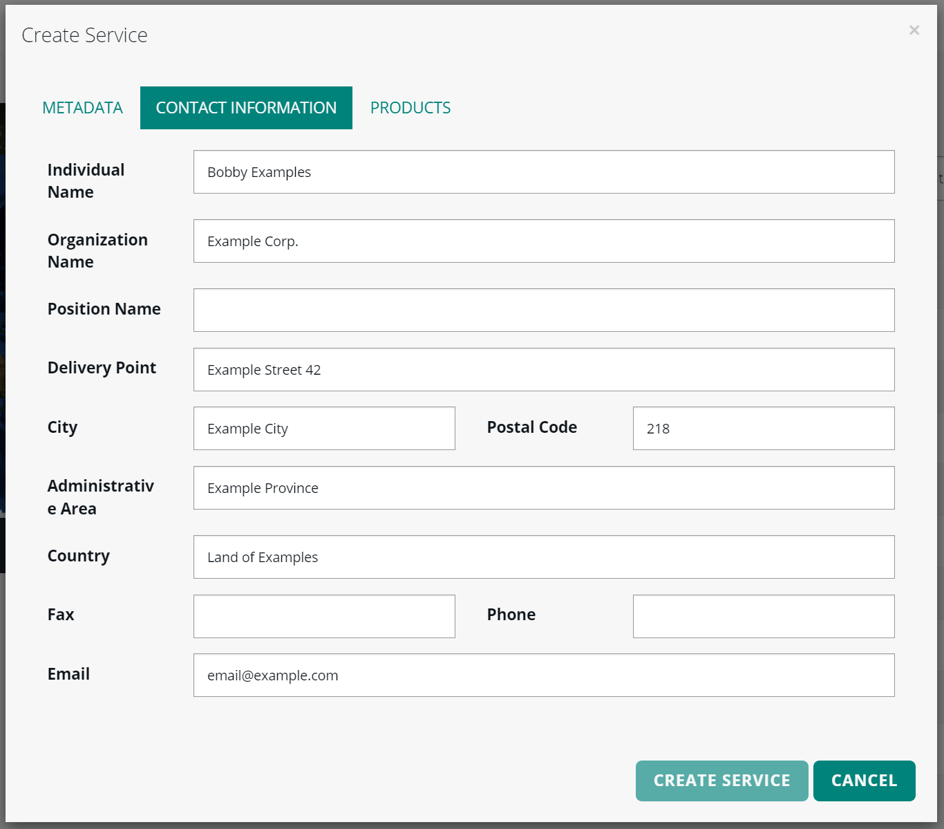
When creating a WMS or WMTS service, you can enter contact information for this service in the Contact information tab. In Figure 2, “Dialog to add contact information for a new WMS service”, you can see the tab with placeholder contact information inserted. If you want to create a DGIWG-compliant WMS or WMTS service, you must enter contact information for those services.
Specifying a metadata default
To avoid setting the metadata each time you create a WMS or WMTS service, you can set the default metadata in the LuciadFusion configuration file. See Configuring LuciadFusion Studio for more information on where to find and how to edit this configuration file.
Configuration file application-fusion.production-template.yml and property fusion.studio.configuration.defaultMetadata
show you how you can set the default metadata in the configuration file.
Legend encoding
DGIWG-compliant WMS or WMTS services must be able to create legends for their layers. By default, they show an icon that depends on the type of model used: elevation, raster or vector. For most use cases, your services need to render a more complex icon. See the article How to customize the legend encoding for WMS or WMTS to find out how you can do that.