Geodesy is the scientific discipline that deals with the measurement and representation of the earth. Many mathematical models have been proposed to approximate the shape of the earth, ranging from flat-earth models to spherical approximations, ellipsoids, and geoids. Spherical and ellipsoidal approximations are used because of their mathematical simplicity. A more accurate approximation is the earth’s geoid, a hypothetical surface that coincides with the earth’s mean sea level. Although the earth’s geoid is considerably smoother than the actual surface of the earth, it is still highly irregular and therefore more difficult to represent and to use in computations. Note that there are many ellipsoid models (for example WGS84 and NAD83) and geoid models (for example EGM2008 and NAVD88) in use around the world.
The following sections describe what geodetic datums and geoids are and how they are supported in LuciadLightspeed.
What is a geodetic datum?
A geodetic datum is a reference from which position measurements are made. A horizontal datum is a known and constant surface on which the positions of points can be precisely expressed. Because of their relative simplicity, ellipsoids are often used as the basis for horizontal datums. A vertical datum is an additional vertical reference for expressing the elevation of points. It is typically based on geoid or ellipsoid models.
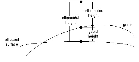
Geodetic datums provide a basis for coordinate reference systems as described in LuciadLightspeed reference systems. For example, a geodetic datum based on an ellipsoid model of the earth’s surface allows to define geodetic lon-lat-height coordinates. The height coordinate may for example be computed with respect to the ellipsoid on which the lon-lat coordinates are defined (ellipsoidal height), or with respect to a geoid model (orthometric height), as shown in Figure 1, “Ellipsoidal versus orthometric heights”. Geodetic datums and the coordinate system based on them are widely used in surveying, mapping, and navigation. Refer to Projections for more information on map projections.
There are many datums in use today, as the basis for even more coordinate reference systems. Because referencing geodetic coordinates to the wrong datum can result in position errors of hundreds of meters, you need to be careful when conversing between coordinates defined with respect to different datums. You can find more information on coordinate transformations in Transformations between coordinate systems.
Using an ILcdGeodeticDatum describes how geodetic datums are supported in LuciadLightspeed. The API reference provides all the necessary details in
the package geodesy. There is a vast literature on geodesy for the interested reader. Literature on geodesy provides a few references.
Using an ILcdGeodeticDatum
LuciadLightspeed provides the interface ILcdGeodeticDatum to represent geodetic datums and support geodetic datum conversions. In this representation, a geodetic datum encompasses
both a horizontal datum and a vertical datum. The horizontal datum is based on an ellipsoid of the type ILcdEllipsoid as described in Using an ILcdEllipsoid. A vertical datum is represented as a height function above this reference ellipsoid (see method getHeight). Most instances, like WGS84, reference height values to their ellipsoid (their method getHeight always returns zero).
TLcdGeodeticDatum is an implementation of ILcdGeodeticDatum which is based on an eight-parameter transformation to a global reference datum. The transformation defines a rotation, a
translation, a scaling and a shift of the prime meridian. This transformation is applied to convert (lon, lat, height) coordinates
from one geodetic datum to the reference datum.
samples/gxy/transformation/geodeticToGrid/GridCalculation)
fTransformation.setSourceReference(fReference);
fTransformation.setDestinationReference(fChosenGeodeticReference);
fTransformation.destinationPoint2sourceSFCT(fLonLatCoordinate,
                                            fReferenceLonLatHeightPoint);
Program: Transforming coordinates to reference geodetic datum shows how to transform lon-lat-height coordinates from one ILcdGeodeticDatum (called fChosenGeodeticDatum) to the reference ILcdGeodeticDatum. The second argument of the method datum2refLLHSFCT is of the type ILcd3DEditablePoint, of which the coordinates are set to the result of the method.
|
In LuciadLightspeed this is called a side-effect method. Side-effect methods are used for performance reasons. In LuciadLightspeed, the names of side-effect methods end in SFCT. |
samples/gxy/transformation/geodeticToGrid/GridCalculation)
fTransformation.setDestinationReference(fChosenGeodeticReference);
fTransformation.sourcePoint2destinationSFCT(fReferenceLonLatHeightPoint,
                                            fLonLatCoordinate);
Program: Transforming coordinates from reference geodetic datum shows the inverse transformation: from the
reference ILcdGeodeticDatum back to the coordinates of the fChosenGeodeticDatum.
By means of these two transformations, it is possible to transform coordinates from any ILcdGeodeticDatum to any other ILcdGeodeticDatum using the reference datum. The reference datum is an internally chosen ILcdGeodeticDatum.
LuciadLightspeed has implementations of most geodetic datums used in the world. These implementations are grouped together
in an ILcdGeodeticDatumFactory. LuciadLightspeed has five implementations of ILcdGeodeticDatumFactory:
-
TLcdNIMA8350GeodeticDatumFactorywhich creates geodetic datums that were defined by NIMA -
TLcdJPLGeodeticDatumFactorywhich creates geodetic datums that were defined by JPL -
TLcdEPSGGeodeticDatumFactorywhich creates geodetic datums based on the EPSG database -
TLcdGenericGeodeticDatumFactorya generic geodetic datum factory -
TLcdGeoidGeodeticDatumFactorywhich creates some common geodetic datums with geoid models as vertical datums. This is currently the only factory creating geodetic datums that do not have ellipsoids as vertical datums. See the API reference documentation forTLcdGeoidGeodeticDatumFactoryto see which geodetic datums with a geoid model as vertical datum are supported.
All factories use WGS-84 as the reference datum.
samples/gxy/transformation/geodeticToGrid/GridCalculation)
int id = fGeodeticDatumFactory.getAliasNames().findID(datum_name);
ILcdGeodeticDatum chosen_datum = fGeodeticDatumFactory.createGeodeticDatum(id);
fChosenGeodeticReference = new TLcdGeodeticReference(chosen_datum);
Program: Create a geodetic datum from a name shows how the particular instance fGeodeticDatumFactory of the class TLcdNIMA8350GeodeticDatumFactory returns a list of alias names of the class TLcdAliasNames. By means of the method findID on this TLcdAliasNames, the id of the ILcdGeodeticDatum with name datum_name is retrieved. Using this id, an ILcdGeodeticDatum called fChosenGeodeticDatum is created by fGeodeticDatumFactory.
In general, the creation of an ILcdGeodeticDatum using an ILcdGeodeticDatumFactory is done by giving the ILcdGeodeticDatumFactory a java.util.Properties object. For the specific ILcdGeodeticDatumFactory properties, see ILcdGeodeticDatumFactory and its implementations in the API reference.
Using an ILcdEllipsoid
An ILcdGeodeticDatum is based on an ILcdEllipsoid. The interface ILcdEllipsoid provides geometrical calculations on an ellipsoid. LuciadLightspeed has a single implementation of the interface ILcdEllipsoid: TLcdEllipsoid.
LuciadLightspeed also provides a utility class TLcdSphereUtil. This class implements the methods of the interface ILcdEllipsoid as static methods. In this implementation the geometrical calculations are done on a sphere. Spherical calculations approximate
the calculations on the ellipsoid, but are more efficient.
The main methods of the interface ILcdEllipsoid are:
-
geodesicDistanceto return the shortest distance between twoILcdPointobjects -
forwardAzimuth2Dto return the azimuth direction of the shortest distance path between twoILcdPointobjects -
geodesicPointSFCTto return the geodetic coordinate of anILcdPointat a given distance in a given azimuth direction
LuciadLightspeed groups together instances of ILcdEllipsoid in an interface ILcdEllipsoidFactory. It has two factories that define most ellipsoids used in the world:
-
TLcdDMA1987bEllipsoidFactory, which creates ellipsoids defined by DMA -
TLcdJPLEllipsoidFactory, which creates ellipsoids defined by JPL
Literature on geodesy
-
Burkehard, Geodesy for the layman, 1985 (http://www.ngs.noaa.gov/PUBS_LIB/Geodesy4Layman/toc.htm)
-
Ewing, Mitchell, Introduction to Geodesy, 1970
-
Bomford, Geodesy, 1952